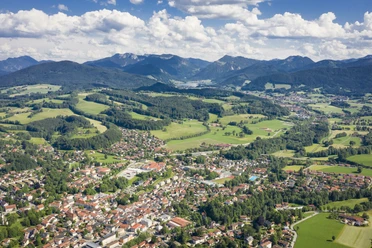
By train to the mountains: From Miesbach via Agatharied to the picturesque Schliersee


- 2:00 h
- 8.58 km
- 103 m
- 2 m
- 685 m
- 788 m
- 103 m
- Start: Miesbach Station
- Destination: Schliersee Station
A tip right at the start: If you do the route on Thursdays, you can stroll through the Green Market, the weekly farmers' market on the beautiful Miesbach marketplace (06:30 to 13:00). There will generally be no shortage of refreshments over the next 8 kilometers. Walking directly along the Schlierach (a tributary of the Mangfall), you hike to Agatharied. Here you can admire the late Gothic church building of St. Agatha and it is worth taking a small detour to the Lantenhammer experience distillery. Then you cross the Schlierach several times and walk right through Hausham, which offers numerous dining options. A small detour must be made to the Huberalm or Huabaoim at the foot of the Huberspitz – but it's worth it.
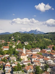
Then continue via Abwinkl to the spa path, which you follow to the north shore of Schliersee. In the spa park, it's time to relax and look at the lake and mountain scenery before heading to the station in Schliersee.
Good to know
Best to visit
Tour information
Cultural Interesting
Familiy-Friendly
Stop at an Inn
Suitable for Pushchair
Author
Regionalentwicklung Oberland
Organization
Alpenregion Tegernsee Schliersee
License (master data)

Nearby