Rotmilan Höhenweg - Relaxing border experience


- 12:30 h
- 45.19 km
- 915 m
- 920 m
- 377 m
- 671 m
- 294 m
- Start: Elsoff, village square or Christianseck, Struthbach parking lot
- Destination: Elsoff, village square
The cross-border circular hiking trail through the Elsoff valley is just under 44 km long.
The pentagonal trail sign leads through the Wittgenstein villages of Elsoff, Christianseck, Diedenshausen, and Alertshausen as well as the Hessian village of Neuludwigsdorf.
Over everything that connects the two federal states soars the red kite, bird of the year 2002.
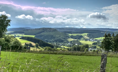
The circular trail, at altitudes between 380 and 675 meters, offers rich nature with magnificent views over the Wittgenstein land and the Eder mountain region. There is plenty of variety on this route and different ways to take it.
Not only demanding hikers come to their own here, but also cyclists. Sections over the heights are especially suitable for families with prams and people dependent on wheelchairs or walkers.
Also, ten feeder paths are marked, which can be used for tours of different lengths. Experience an interesting "border experience" with impressive panoramic views!
Good to know
Best to visit
- suitableDepends on weather
Tour information
Loop Road
Loop Road
Suitable for Pushchair
Author
BLB-Tourismus GmbH
Organization
BLB-Tourismus GmbH
License (master data)

Nearby


Download GPX file