Through the Zwotaer Land 2

- 4:37 h
- 15.90 km
- 342 m
- 342 m
- 572 m
- 799 m
- 227 m
- Start: Zwota hiking parking lot (Hammerplatz)
- Destination: Zwota hiking parking lot (Hammerplatz)
"High fire in the Elster Mountains"
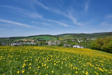
Hikers can expect not only numerous impressive views, but also plenty of information. With the "Soldier's Grave", the "Three Rainstones" and the surveying column (trigonometric point), there are 3 historically significant points to discover on this tour. At 803m, the Hohe Brand is the highest elevation in the Elstergebirge.
Good to know
Best to visit
Directions
Our hike begins at Hammerplatz in the direction of Markneukirchen. We cross the Zwota and the railroad line and turn right before the cemetery onto the Höhensteig Klingenthal (green) and the Vogtlandweg (blue) to Hüttenbachtal. There we turn left and continue along the Höhensteig and Vogtlandweg. We pass the large and small Hüttenbach ponds (built in 1934/35 by the Reich Labor Service). The hike continues to the left along the "Notstandsweg" in the direction of "Alte Klingenthaler Straße" to a refuge. This path was built during the period of high unemployment after the First World War and paid for by the employment offices with emergency money. At the refuge on the "Alte Klingenthaler Straße", we turn left about 40 m in the direction of Klingenthal and reach the soldiers' grave. Two days before the end of the war, an Austrian non-commissioned officer was shot at this spot.
We follow the yellow markings in the direction of the Landesgemeinde. The Landesgemeinde belonged to the parish of Klingenthal from 16.02.1698. The first inhabitants were the Erlbach sub-forester and gamekeeper Johann Weller and his father Adam Weller. The yellow path leads to the right to the rear raft pond. However, we turn left towards the border of the Czech Republic via the "Erlbacher Bergweg" (yellow) and after 50 m reach the "Drei Rainsteine" (Saxon, Bohemian and Hartenberger Herrschaft).
We walk about 200 m back along the Vogtland Panorama Trail and then turn left on the red marked Eisenach-Budapest ("EB") hiking trail, which also forms the Zwota-Erlbach district boundary, to the "Wegespinne". Continuing the hike on the Höhenstein Klingenthal (green), the Kammweg and the Vogtlandweg (blue), we see the former horse fountain on the left (the horses that did the heavy logging work were watered here) and reach the "Erlbacher Jagdhütte".
We then continue straight ahead on the ridge path (yellow) to the surveying column (trigonometric point 796 m) at the "Hoher Brand" (803 m highest elevation in the Elstergebirge). After 300 m, we turn right onto the yellow trail to the radio tower and reach the Höhensteig Klingenthal (green) again. Before that, the "Pferdestallweg" turns left towards the B283. There used to be a stable there where horses were kept overnight. We continue on green until approx. 300 m before the Zechenbach football pitch and then turn right onto yellow towards Hüttenbachtal.
The last part of the hike we stay on the Höhensteig Klingenthal (green) to the Zwota cemetery and end our tour on blue/yellow at Hammerplatz.
Tour information
Loop Road
Equipment
Directions & Parking facilities
Vogtland Bahn, Zwota stop (approx. 400m away)
Bus, stop Hammerplatz (directly at the hiking parking lot)
Additional information
Author
Tourismus Marketing Gesellschaft Sachsen mbH
Organization
Vogtland - Sinfonie der Natur
License (master data)
Vogtland - Sinfonie der Natur

Author´s Tip / Recommendation of the author
Safety guidelines
Map
Dr. Barthel, Vogtland music region, edition 7
WanderTouren Durchs Zwotaer Land (available at Gasthof zum Walfisch, Gasthof Zwota and Ferienhotel Zwotatal)
Nearby


Download GPX file