"Erlbacher Mountain King" - Mountain Runs


- 4:55 h
- 16.51 km
- 612 m
- 612 m
- 515 m
- 762 m
- 247 m
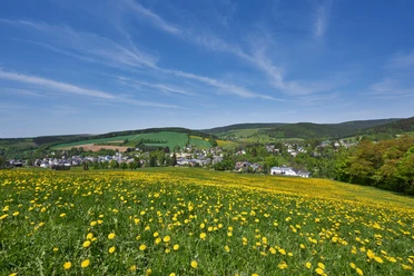
Hiking and Upper Vogtland have always belonged together. The mountain king takes you along mighty mountain slopes, small mountain meadows, winding paths, or the „diretisima“ straight uphill. Perfect resting spots at the top. Pure hiking joy. You casually start in the sunny valley at Erlbach, challenge your calves on the climb to the Hoher Stein – at the top, you are already in the Czech Republic. You almost shift into trail running on the Kegelberg: fine paths through deciduous and mixed forests, spiced here and there with steep ascents. Snack at the ski hut by the lift. You trudge up through giant beeches to the Berghäuser viewpoint, passing the small Gopplasgrün. A little goosebumps are allowed at the old judgement site. And soon you look exhausted and deeply relaxed from the Spornreuth viewpoint towards the southwest. The afternoon sun warms you. What a royal hike!

Waypoints


Good to know
Best to visit
Tour information
Loop Road
Loop Road
Author
Saskia Prelec
Organization
Vogtland - Sinfonie der Natur
License (master data)
Saskia Prelec

Nearby

Download GPX file