Trails dream loop Border View Path


- 4:30 h
- 13.57 km
- 239 m
- 239 m
- 197 m
- 334 m
- 137 m
- Start: Heining Church in Leidingen, 9 Rue de la Frontière Leiding, 57320 Heining-lès-Bouzonville, France
- Destination: Heining Church
In Leidingen, the residents are daily cross-border commuters. The street running on the border is called "Neutrale Straße" in Germany and "Rue de la Frontière" in France. The French church stands outside the village on a hill at the edge of the forest. This is also where the hiking route starts. Through the Eberswald and later through the Dennenwald, the route leads towards Heining lès Bouzonville. Near the edge of the forest, shortly before Heining, the trenches from the Second World War are still visible.
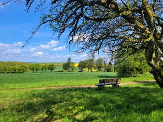
The further we walk, the wider the view into the land, beyond Saarland into France, Luxembourg, the foothills of the Hunsrück and the Schaumberg.
Above Heining is a simple wooden cross. This place was fiercely contested during the Second World War. Quiet, wide land in the border area. The silence seems to become audible in a region where the border has completely disappeared. One country merges into another.
Behind the village Ihn, the trail leads between meadows and fields over open farmland with views over the heights of the Saargau.
A paved road leads back to Leidingen. On the left and right of the road stand old boundary stones. Between them, the road runs through no man's land on neutral ground directly to Leidingen.
The route was rated with 61 experience points by the German Hiking Institute!
Good to know
Best to visit
Tour information
Cultural Interesting
Loop Road
Loop Road
Author
Frank Polotzek
Organization
Saarland
License (master data)

Nearby


Download GPX file