Westlausitz Circular Route


- 14:50 h
- 60.17 km
- 408 m
- 383 m
- 249 m
- 395 m
- 146 m
- Start: Stations Arnsdorf, Pulsnitz, Bischofswerda, Großharthau
- Destination: Stations Arnsdorf, Pulsnitz, Bischofswerda, Großharthau
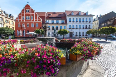
The circular route connects some of the most beautiful landscapes such as the Luchsenburg or the legendary Massenei in the Westlausitz. Explore the Westlausitz mountain and hill region and visit beautiful natural spots and cultural sights such as the gingerbread town of Pulsnitz, the Baroque castle Rammenau, the Butterberg, the animal and cultural park in Bischofswerda, or the castle park in Großharthau. Variety is key on the circular route – nature and culture are equally to be discovered and enjoyed.
There is the possibility to start the circular route at 5 train stations (Arnsdorf, Kleinröhrsdorf, Pulsnitz, Bischofswerda, Großharthau). Hiking car parks, where cars can be parked for several days, are located in Arnsdorf (at the station), Pulsnitz (Schützenplatz), Ohorn (at the community center), Großharthau (at the Volkspark), and at the guesthouse on the Butterberg. It is recommended to comfortably hike the approximately 60 km long trail over 5 days, so that the cultural sights can be enjoyed at leisure. Numerous accommodations in the region are ready and look forward to welcoming guests.
Waypoints

Good to know
Pavements
- Street (6%)Asphalt (22%)Gravel (41%)Trail (22%)Path (9%)
Best to visit
- suitableDepends on weather
Directions
The hiking trail is continuously marked with its own logo.
From the station in Arnsdorf, you pass through the small village towards the Massenei forest area. Before reaching it, the trail leads over the Tannenberg, which offers a view of the surrounding region. Through the Massenei forest, the trail leads to Kleinröhrsdorf and further through the Niederforst to Pulsnitz, the nationally known gingerbread town with many sights. After a short city walk, the trail passes through a small forest area to the municipality of Ohron, which has an interesting local history museum in the community center. Beyond the village begins the large forest area of the Luchsenburg, with the eponymous forestry house. The actual hiking trail now leads directly to Rammenau, but from here there is the possibility to take an alternative route over the Hochstein, the highest elevation of the Westlausitz. This will require about 3 more hours. Upon arrival in Rammenau, hikers can visit the nationally famed Baroque castle with its castle park. The hiking trail passes by the "Old Prison" and the "Old Smithy" through the entire village and continues to the northern ridge trail, which leads hikers directly to the Butterberg, the "local mountain" of Bischofswerda. Heading south, you then leave the mountain towards the town center, which is reached after a short time. Besides the animal and cultural park, the historic market and churches can be visited here. The trail then runs via the village of Goldbach west to the municipality of Großharthau, which is well known for its castle park and the twice-yearly "LebensArt", an art and culture market. The last section of the path leads hikers once again through the Massenei until reaching the starting point in Arnsdorf again.
Tour information
Cultural Interesting
Loop Road
Stop at an Inn
Tour with Dog
Directions & Parking facilities
- Parking
- Arnsdorf (at the station)
- Pulsnitz (Schützenplatz)
- Ohorn (at the community center)
- Großharthau (at the Volkspark)
- guesthouse on the Butterberg
Public transportationby train line RB 34
- stations Kleinröhsdorf and Pulsnitz
by train lines RB 60, RB 61, RE 1, RE 2
- stations Arnsdorf, Großharthau and Bischofswerda
Additional information
- Many outdoor swimming pools along the hiking trail offer wonderful refreshment in summer, e.g., the Karswaldbad in Arnsdorf, the Walkmühlenbad in Pulsnitz, the outdoor pool in Bischofswerda, as well as the Masseneibad.
Author
Region Westlausitz
Organization
Das Landschaftswunderland Oberlausitz
License (master data)
Region Westlausitz

Author´s Tip / Recommendation of the author
5-day route
1st stage: from Arnsdorf to Pulsnitz, approx. 14 km
2nd stage: from Pulsnitz to the Luchsenburg forestry house, approx. 12 km
3rd stage: from the Luchsenburg forestry house to the Butterberg Bischofswerda, approx. 9.5 km
4th stage: from Butterberg Bischofswerda to Großarthau, approx. 11 km
5th stage: from Großharthau to Arnsdorf, approx. 13.5 km
Map
Sachsenkartographie - »Hiking and Cycling Map Westlausitz«, 1:33,000, ISBN 978-3-86843-018-9
Dr. Barthel Verlag - »Cycling and Hiking Map Bischofswerda, Pulsnitz, Stolpen and Surroundings«, 1:35,000; ISBN 978-3-89591-144-6
Nearby


Download GPX file