Bad Suderode - Anhalt Salstein - Preußenturm - Bad Suderode


- 2:45 h
- 6.46 km
- 219 m
- 220 m
- 224 m
- 390 m
- 166 m
- Start: Bad Suderode Information, Rathausplatz 2, 06485 Quedlinburg OT Bad Suderode
- Destination: Bad Suderode Information, Rathausplatz 2, 06485 Quedlinburg OT Bad Suderode
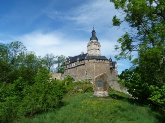
From the tourist information, walk through Schwedderbergstraße to the spa park. Passing the Behringer fountain, first follow the signs for hiking trail 44 J (green square) towards Friedrichsbrunn. The path takes you past the rock garden, the Felsenkeller inn, the Lessing cave, a water wheel, and a pond. Beyond the pond, the path forks. From here, follow the signs to Anhalt Salstein (steep ascent). At the first fork, turn right (small R4 trail mark on a tree stump!). The path now becomes very narrow and very steep. The strenuous climb is rewarded with a great view from the "Felskanzel" viewpoint. From there, it is only a few meters to stamp point no. 186 – Anhalt Salstein. From there, follow path 44 G (red cross) towards Spinne (shelter). Just before the "Spinne," turn left into Heckenrosenweg. Follow this towards "Löffel," Grenzweg, Preußenturm (red cross). At Preußenturm is stamp point no. 185. From the tower, there is a nice view over Bad Suderode and the Harz foreland. From here, follow the signs back to the spa park Bad Suderode.
Good to know
Best to visit
Tour information
Loop Road
Loop Road
Author
Quedlinburg Information
Organization
Harz: Magische Gebirgswelt
License (master data)

Nearby


Download GPX file