Gravel Tour 3: Tour on the right bank of the Elbe via Diesbar-Seußlitz to Glaubitz


- 5:35 h
- 77.43 km
- 382 m
- 382 m
- 95 m
- 183 m
- 88 m
- Start: Parking lot on the right bank of the Elbe in Meissen
- Destination: Parking lot on the right bank of the Elbe in Meissen
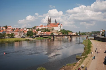
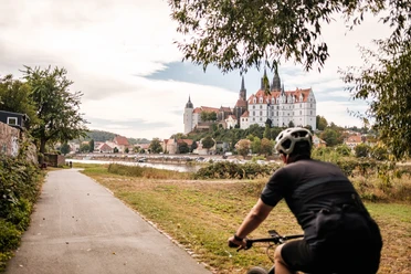
The starting point is Meissen. From the parking lot on the Elbe, you’ll catch your first glimpse of the city’s landmarks—Meissen Cathedral and Albrechtsburg Castle—before heading north through the outskirts of the city. The trail winds past the idyllic fields and ponds of the “Heiliger Grund” hiking area. The first climb is rewarded with a view of Proschwitz Castle, Saxony’s oldest private winery. A brief stop here is worthwhile not only for the architecture but also for the adjacent wildlife reserve, where you can observe native wildlife.
The route continues over challenging gravel sections through the Golkwald, where the Heidegräber and the Nonnenstein lookout point are worth a detour. The route winds through the Seußlitzer Grund, a nature reserve that delights visitors with its diverse flora and fauna. There, you’ll also have the opportunity to enjoy “Saxony’s Most Beautiful Wine View 2020.” In Seußlitz, the picturesque castle park—which was laid out as a pleasure garden between 1722 and 1733 and captivates visitors with its combination of French and English garden styles—invites you to linger. Also worth seeing are the castle church and the “Haus des Gastes” with its adjoining café. Perched above the park is the Heinrichsburg, a garden house built in 1728 by the then lord of the castle, Heinrich von Bünau, based on plans by George Bähr, from which you also have a fantastic view of the Elbe region.
The route continues across expansive fields toward the Kleinraschützer Heide near Großenhain. Information signs along the way recount the eventful history of this landscape, which once served as a military training ground. In Großenhain itself, the city park invites you to take a relaxing break. Another real highlight along the route is the impressive Baroque garden in Zabeltitz, which, together with the palace and the “Old Castle,” forms a charming ensemble of Baroque and Renaissance architecture.
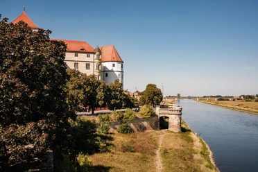
Through the romantic Röderau Forest, past the Großes Gabelwehr, the route continues on quiet side roads and farm trails through Bauda and Colmnitz to Glaubitz. Small villages, tree-lined dirt roads, and gentle inclines make this section particularly relaxing for gravel riders. The Glaubitz Forest, with the pristine Birkenteich and Eselsteich ponds right along the path and the popular forest swimming area, is another highlight for gravel enthusiasts. In Glaubitz itself, it’s worth taking a short detour to Glaubitz Castle, which impresses with its historic architecture. In addition, the historic railway facilities bear witness to the town’s industrial past.
The return trip takes you along the Elbe Cycle Route to Diesbar-Seußlitz. From there, the route passes through the Seußlitzer Grund and the Golkwald once more before heading back to Meissen via Zadel and Diera. The final view of the cathedral and Albrechtsburg Castle rounds out this impressive gravel tour.
Terrain
34.2 km of asphalt, 17.8 km of gravel path, 14.7 km of natural trail, 8.8 km of road, 0.7 km of trail
undulating route profile with moderate to steep climbs
Waypoints


Good to know
Pavements
Best to visit
Directions
At Schloss Proschwitz, the route turns right again onto Proschwitzer Straße. At the edge of the residential area, turn left onto Thomas-Müntzer-Straße. Follow this road to Winkwitz, then turn right onto Weg Eichberg. After crossing Dieraer Weg, keep left on a dirt road leading toward Naundörfel. After passing through the small village, follow Gosetal Street until, after about 650 m, a left-hand curve leads to a dirt road that crosses the Kleine Gose and the Gosebach. At the next fork in the road, keep left, ride along the edge of the forest, and after about 1.8 km, at a crossroads, take the second road on the right to cross Kreisstraße 8010.
Continue on Radewitzer Straße through the Seußlitzer Grund, turn left onto Forststraße, and reach the village of Seußlitz. Here, turn right at the first intersection onto Bergstraße. After a sharp right turn and a gentle left turn, follow the road to the left onto Kirchberg.
You’ll
now ride along the road past the cemetery toward Neuseußlitz. Here, follow Kirchweg to the right and, at the next opportunity, turn right again onto Neuen Weg.
After about 1 km, turn left at an intersection onto a paved dirt road and follow it to the next fork in the road. From there, continue left on the road until the next fork, where you turn right again onto a dirt road. Follow this road to Medessen, where you turn right again onto Riesaer Straße, which merges into Großenhainer Straße as you leave town. After crossing the railroad tracks, follow the county road out of town and turn left after about 350 m toward Großenhain. Cross the railroad tracks again and continue straight ahead to the next fork, where you turn left onto Medessener Straße. This
road
continues straight past the wastewater treatment plant to the village of Skassa.
In Skassa, turn right briefly onto Rieaser Landstraße, but then immediately turn left again onto Pflasterstraße. After a left-hand curve at the Zürner memorial stone, turn right onto Rödertalstraße to leave the village. Cross the Große Röder River and a canal, then follow Skassaer Straße toward Großenhain. After about 500 meters, at a three-way fork, turn right onto Am Stadtpark, then left onto Wildenhainer Straße, and immediately right again onto Doktor-Külz-Straße. Follow this road until you finally leave the residential area. After crossing the B98, keep left and follow Waldaer Straße all the way to Kleinthiemig. Drive straight through the town on Großehainer Straße; as the road continues, it leads via Siedlerstraße to Walda. At the first major intersection, follow the ring road to the right. At the next fork in the road, turn left onto Zabeltitzer Straße. After about 100 meters, turn left again onto a dirt road that meets Waldaer Straße just before Zabeltitz. At the entrance to the town, turn left onto Kastanienallee. At the parking lot of the Zabeltitz Baroque Garden, turn left again and cross through the park. Just before the Elligastbach stream, turn left once more, cross the fork weir, and—keeping to the left—pass the mill and follow Mühlweg to Bauda.
Via the Baudaer Mühlweg, you’ll reach Baudaer Hauptstraße on the left; in the town center, turn right onto Lindenstraße, which later becomes Riesaer Straße. Continue along this road, and after a right-hand curve, turn left onto the Schulweg toward Colmitz. There, the Schulweg merges into Baudaer Straße and then into Glaubitzer Weg. Follow this road straight ahead to Glaubitz. Here, take a sharp left onto Großenhainer Straße/B98 and follow it to the edge of the settlement, where you turn right onto Feldstraße.
After about 1.5 kilometers, turn right again, through the Glaubitzer Wald. To do this, turn left at the second intersection, right at the next fork, and then left again. Turn right onto the next path, pass the Eselteich and Birkenteich, and then turn left toward the Hexentanzplatz. Once there, keep to the right again. Just before the Natur- und Waldbad, turn left and continue along the path by the stream; pass the Küchenteich and Schloss Glaubitz on your left, continuing along the dirt road until you turn right onto Nünchritzer Straße at the Zschaitenbach and follow it back toward Glaubitz.
At the roundabout, take the third exit onto Poststraße, and at the first intersection, turn right onto Oststraße until you reach Bahnhofstraße. Cross Glaubitz Station to the left and follow the adjacent bike path along the Grödel-Elsterwerda Raft Canal. The path continues parallel to the canal until
you
reach Elbstraße. Turn left there.
After Grödel, follow the Elbe Bike Path to the right, which leads back via Nünchritz, Leckwitz, and Merschwitz to Seußlitz. At the castle park, turn left onto Forststraße and then again onto Radewitzer Straße through the Seußlitzer Grund. At Löbsal, leave the familiar route by turning right onto the K8010. In Löbsal, the route then leads across the village square, turning left onto Kirchenweg and out of the village into the Golkwald. There, at the Nonnenstein, turn slightly right onto Querweg and follow it to the street Zum Forsthaus in the village of Golk. Here, turn left onto Zum Forsthaus and continue following the road through the forest. At the next intersection, cross the street Am Gosebach straight ahead and continue straight through the fields, along the Katerbach, toward Neumühle. Here, cross the S88 and then continue right toward Kleinzadel.
After about 500 m, turn left onto a dirt road and, at the next fork, turn left again toward Zadel. In Zadel, you’ll reach Schulstraße; follow it to the left and, after about 100 meters, turn right onto Kirchstraße. Follow this road past the cemetery to the end, then turn left onto the path that continues straight ahead, running along the top of the vineyards.
After a left-hand curve, you’ll rejoin the S88 in Diera; follow it briefly to the right. Then, after about 200 meters, turn right again onto Eisenacher Straße. At the next intersection, continue straight ahead on the dirt road toward Rottewitz. After a sharp right turn and a sharp left turn, you’ll reach Rottewitzer Straße and turn right onto Winkwitzer Straße.
In Winkwitz, continue along Winkwitzer Straße, keep to the right after about 70 meters, and ride down Heuweg to the Elbe. Here, cross Elbtalstraße and turn sharply left onto the Elbe Bike Path, which you then follow until you return to the starting point, “Parkplatz an der Elbe” in Meissen.
Tour information
Cultural Interesting
Stop at an Inn
Directions & Parking facilities
Take the A4, exit at Dresden/Altstadt, and continue on the B6 to Meissen
or take the A4, exit at Wilsdruff, and take the local road to Meissen
S-Bahn Line 1 from Bad Schandau via Dresden
By bus:
Bus 401 from Coswig
Bus 404 from Cossebaude
Bus 407 from Nünchritz
Bus 409 from Großenhain
Bus 411/421 from Weinböhla
Bus 413/414 from Tanneberg
Bus 415 from Löbsal
Bus 416 from Lommatzsch
Bus 418/412 from Nossen
Bus 422/417 from Ziegenhain
Bus 426 from Naustadt
Bus 428 from Wildsdruff
Bus 446 from Riesa
Timetable Information | VVO Navigator – Your Mobility Portal for Dresden and the Region
Author
Dresden Elbland Redaktion
Organization
Dresden Elbland
License (master data)
Dresden Elbland Redaktion

Safety guidelines
The gravel bike routes published here are purely digital route recommendations. Riding these routes is entirely at your own risk. We assume no liability whatsoever for accidents of any kind, including hazards typical of forest areas (e.g., falling branches, falling trees, unforeseeable obstacles along the way). Please ride attentively and with due caution at all times. Be sure to follow local signs and regulations.
Our recommendations for safe and considerate gravel biking:
1. Use only existing trails and do not stray from the recommended route. This helps protect nature and prevent erosion.
2. Respect other trail users: Be considerate of hikers, other cyclists, and horseback riders. Yield the right of way and communicate politely.
3. Always adjust your speed to the prevailing conditions: Take into account your riding skills, trail conditions, the weather, and other trail users.
4. Protect animals and nature: Stay on the trails, avoid riding at dusk or at night, keep your distance from wildlife, and do not leave any trash behind.
5. Take your trash with you: Everything you bring—from packaging and tissues to spare parts—must be taken back with you.
6. Wear appropriate gear: A helmet, lights, tools, spare parts, possibly snacks, and plenty of water are standard equipment.
7. Plan ahead: Check the weather and trail conditions, make sure your bike and gear are in good shape—and familiarize yourself with the route beforehand.
Nearby

.jpg")