Kappelrodeck - Wine hike at the Witch (Official route)


- 2:00 h
- 6.19 km
- 209 m
- 209 m
- 211 m
- 336 m
- 125 m
- Start: Hiking information board at Kappelrodeck station
- Destination: Hiking information board at Kappelrodeck station
The starting point for this wonderful round through the vineyards is the hiking information board at the station.
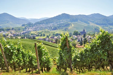
After a small ascent we reach the “Dasenstein”, that rock formation in the vineyard from which the famous wines of the “Witch of Dasenstein” take their name. From here you can enjoy a fantastic view over the town and the Rhine plain, in good visibility even as far as Strasbourg Cathedral!
Via paved paths through the vineyards we reach the car park behind the “Schützenhaus”. The yellow lozenge marks the way further through a small chestnut forest before we reach the vineyards again at Langenberg. We head to Lammhof and cross the main road at the railway crossing. Past the Heidenhöfe, and by the Heidenhof distillery with its “tasting barrel”, we climb steeply to Ganzeckhof (with a drinking fountain and a great playground). From there we follow the paved road down for a bit, then turn right towards “Zuckerberg Castle”. Through a splendid park we reach the popular café with garden terrace and art gallery. After a coffee break, we go through the Green Corner to the town centre, the marketplace, with its restaurants and beer gardens, and back to the starting point at the station.
Good to know
Best to visit
- suitableDepends on weather
Tour information
Loop Road
Loop Road
Stop at an Inn
Suitable for Pushchair
Author
Nationalparkregion Schwarzwald - Achertal
Organization
Nationalparkregion Schwarzwald - Achertal
License (master data)
Nationalparkregion Schwarzwald - Achertal

Nearby


Download GPX file