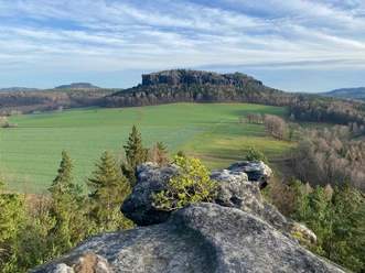
- Photos & Map
How would you like to arrive?
- Description
- Good to know
- Nearby
Download GPX file
- 4:15 h
- 10.80 km
- 330 m
- 330 m
- 177 m
- 313 m
- 136 m
- Start: Königstein Fortress parking garage | Am Königstein stop (to the fortress)
- Destination: Königstein Fortress parking garage | Am Königstein stop (to the fortress)
Parking garage of Königstein Fortress - Thürmsdorf - Götzinger Cave - Kleiner Bärenstein - Großer Bärenstein - Thürmsdorf Castle - Malerweg chapel - forest brook - parking garage Königstein Fortress
Good to know
Pavements
Best to visit
Directions
The hiking route leads beside the parking garage of the Königstein Fortress to the underpass of the B172. Here, follow the red dot straight ahead, cross the main road, and walk along the edge of the road towards Thürmsdorf. After the bridge, a path leads uphill to the left. At the forest edge and along the field border, you follow a newly created path to Thürmsdorf. A glance over your shoulder reveals a wonderful view of the Lilienstein. Arriving at Thürmsdorf street, follow it to the left at first and then turn right to Thürmsdorf Castle. A short stop at the chocolate manufactory and a small walk in the castle garden are recommended here.
In front of the castle, continue left along the path. After crossing the street, you soon arrive at the Götzinger Cave, where you can find a dry picnic spot even in drizzly weather. It has a depth of about 25 m. In various maps, it is also referred to as the "Diebskeller" (thieves' cellar).
Now follow the signposts and climb the Kleiner Bärenstein, which is higher than the Großer Bärenstein. In 1847, a mountain guesthouse was built up here. Around 1902, two bears were even kept in a pen here. Unfortunately, the guesthouse fell into disrepair after the war and today can only be guessed at by its foundations; however, the stunning view southeast with the majestic Lilienstein compensates for this.
The same path leads back downhill. At the fork, however, continue straight ahead. After about 300 m, the hiking route continues unmarked to the right along the forest edge, crosses a path, and then leads onto the Großer Bärenstein. Small trails at the top lead to several viewpoints. For the descent, you can choose the adventurous variant via the Riegelhofstiege (a climbing section; in wet and cold weather, descent via the Riegelhofstiege is not recommended) or take the way back and turn right at the forest edge. In the first variant, you descend the Riegelhofstiege over partly large rock slabs with bigger gaps. At the bottom, the path continues to the right under tall climbing peaks and meets a comfortable forest path.
Alternatively, you can also take the route from the "Schneiderweg" junction towards "Hermann-Schneider-Weg" and hike the Riegelhofstiege from bottom to top.
Here you go right in a large arc along the foot of the Großer Bärenstein and straight ahead at the larger crossroads. You cross the country road and then walk first along the forest edge, later over the field path back to Thürmsdorf. Behind the castle, you meet the Malerweg, which you follow up to a long-forgotten viewpoint.
This viewpoint is named after the painter Johann Alexander Thiele, who created a painting here with a view of the Elbe and Königstein Fortress. Surprisingly, there is also an old round building here that has been reconstructed and converted into the Malerweg chapel. The so-called Biedermann Mausoleum was built as part of the castle complex. Here, the rock face drops steeply one hundred meters to the Elbe and, after clearing, offers a deep view of the Elbe loop.
We go back a bit and walk left downhill past an orchard to the village street. Follow it keeping right, slightly uphill, and turn sharply left at the fork. Here you meet the Malerweg again. After the last house, a path leads left down into the forest into a rustic valley with a small forest brook. The last section climbs uphill on the right and after crossing the road reaches the first section of the route, arriving at the fortress parking lot and thus the end point of the hike.
GPS data updated 2022
Tour information
Loop Road
Summit
Equipment
Hiking boots are recommended; no food stops along the way
Directions & Parking facilities
Follow the B172 / signs to Königstein Fortress
Parking garage Königstein Fortress
Arrival/ Departure:
Stop "Am Königstein" (Fortress)
Line 246 ((Pirna-Copitz -) Pirna - Naundorf - Weißig - Leupoldishain - Königstein)
Line 241 (Pirna - Königstein - Bad Schandau - Hinterhermsdorf)
or from the town of Königstein
S-Bahn S 1 and Festungsexpress start at Reisigerplatz to the Königstein parking garage
Additional information
Literature
Buy here: Hiking guides
Author
Tourismusverband Sächsische Schweiz
Organization
Tourismusverband Sächsische Schweiz
License (master data)
Author´s Tip / Recommendation of the author
For family members who are "hiking couch potatoes," there is the possibility at the start or end point to spend time in the high ropes course, mini golf, or at Königstein Fortress.
Safety guidelines
You should be very sure-footed on the section "Descent from the Großer Bärenstein" (Riegelhofstiege) or choose the easier descent. In wet and cold weather, descent via the Riegelhofstiege is not recommended.
On both table mountains, there are hardly any railings at the viewpoints, so appropriate caution is advised.
Map
Nearby


