To the Hohenwaldeck Castle Ruin


- 3:00 h
- 9.51 km
- 308 m
- 308 m
- 776 m
- 1,051 m
- 275 m
- Start: Schliersee
- Destination: Schliersee
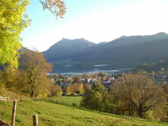
Above Schliersee, accompanied by wonderful views, you follow the traces of the past here. Anyone who lets their gaze wander along the way and from the viewing platform of the ruin will recognize the Schliersee local mountains and the peaks in the Spitzing area. On the way back along the lake, if the weather is suitable, a jump into the lake is possible. There is no shortage of refreshment options, as several gastronomic establishments can be found both in Fischhausen and Schliersee.
Good to know
Best to visit
suitable
Depends on weather
Tour information
Cultural Interesting
Familiy-Friendly
Loop Road
Loop Road
Stop at an Inn
Author
Regionalentwicklung Oberland
Organization
Alpenregion Tegernsee Schliersee
License (master data)

Nearby


Download GPX file