Ems-Jade Canal Cycle Path

Tip
82.26 km long
Difficulty: easy
Condition: very easy
Great panorama
Biking
  • 8:00 h
  • 82.26 km
  • 11 m
  • 12 m
  • -2 m
  • 9 m
  • 11 m
  • Start: Emden Inland Harbor
  • Destination: Querfeuer Alte Mole Wilhelmshaven
The Ems-Jade Canal was built between 1880 and 1888. Its creation was due to the wish of the Prussians to connect their naval port Wilhelmshaven, which at that time was an exclave in the then Grand Duchy of Oldenburg, by waterway with Prussian East Frisia. At that time, Wilhelmshaven politically belonged to East Frisia. Wilhelmshaven grew very quickly and also promised to become a good market for agricultural products, building materials, and peat, which could best be transported by water. Because there were only a few roads and large parts of the land were very wet. In East Frisia, the drainage of the land had therefore always been important. Thus, improving the drainage conditions in the higher-lying, inner part of East Frisia was another important purpose of the Ems-Jade Canal. It took up the water and led it via the Emden harbor into the Ems and via the Wilhelmshaven harbor into the Jade Bay.

For the construction of the current canal, the predecessor of the Ems-Jade Canal, the "Treckschuitenfahrtskanal" running between Emden and Aurich, was used. This served the transport of people, animals, and goods using horse-drawn "Schuiten" (inland vessels) that operated on a schedule. At the halfway point in Middelhaus, horses were changed and refreshments taken. The towpaths were wide enough to be used also by coaches and landaus and for urgent messages by the "Riding Post". (Source Wikipedia)

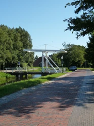
Today the post no longer rides and the paths along the canal can be used for other purposes. Cycling tourism is a very good option! On the Ems-Jade Canal Cycle Path you cycle "across" the East Frisian Peninsula and discover the varied and interesting inland of our beautiful region. This cycling route is a ramble through the landscapes of East Frisia. East Frisia is a coastal region and roughly consists of three different landscape types with different elevation levels: the marsh, the geest, and the moor. These three natural landscapes exist in East Frisia and you will experience them all on your way! At first glance, the difference between these landscape types is not so obvious, as the first impression of East Frisia is often: "everything is flat". However, an East Frisian proverb hints at differences: "Ostfresland is as en Pankook, de Midden is am dicksten und de Rand is am fettesten." (East Frisia is like a pancake, the middle is the thickest and the edge is the fattest). The comparison to the pancake shows that climbs can hardly be expected on this cycling tour. Occasionally going up the dyke or a bridge, that's it. So you can take it very easy! Roam through East Frisia, discover lakes (seas) at low moorland locations, at the edge of the geest in transition to the marsh, dykes inland, and "climb" the geest, the highest landscape type of the East Frisian Peninsula. Everywhere on the tour you learn something about the landscape and discover an ancient cultural landscape and its nature.

Good to know

Best to visit

suitable
Depends on weather

Directions

It starts at the old Emden inland harbor. Take it easy and first enjoy the view over the water lying in the heart of the city, the museum ships, and the Emden city center. At the digital information pillar, you can already take a look at the route ahead of you. Then continue always along the water to the Kesselschleuse. A cultural-historical building and a remarkable, listed rarity. Information about the function and special features of the Kesselschleuse can be found on site. The ride continues directly on the canal embankment to the "Uphuser Klappe" (Klappe means drawbridge). There the path changes from the embankment to the road running parallel to the canal. From here, the Ems-Jade Canal Cycle Path runs together with the 3-Seas Trail, which connects the three inland lakes Großes Meer, Loppersumer Meer, and Hieve between Emden and Aurich. This is an important breeding ground for meadow and reed birds and a resting area of national and international importance for Nordic geese and wading birds. At the Großes Meer, you learn more about the nature of these shallow lakes. Soon you reach the Woldenweg. From the intersection with Herrenmeedeweg, a "detour" of the Ems-Jade Canal Cycle Path continues over the Woldenweg to the Großes Meer, with all the tourist infrastructure of the municipality of Südbrookmerland. The route is signposted. The main route continues over the Wolde and Herrenmeedeweg to the "Mittelhaus". At Mittelhaus, the path takes you over the bridge. Then follow the roads Zum Mittelhaus, Hinterfennenweg, and Loogstraße until you reach the canal again in Fahne in the municipality of Ihlow. Over the bridge, it continues on the old post road towards Aurich. Passing the Kukelorum lock, it goes straight into the town. Via Grüner Weg, the roads Am Kanal and Am neuen Hafen, Hasseburger- and Tannenbergstraße, you reach the harbor of Aurich. Here the Ems-Jade Canal makes a "bend"; follow the signage through the harbor and so reach the towpath again. In the pleasant shade of many trees, follow it until you reach Marcardsmoor, a district of the town Wiesmoor. On this section of the route, you pass through a charming hedgerow landscape. At Marcardsmoor, you change to the other side of the canal at the bridge and ride south over Upschörter Straße and then Auricher Weg to the next bridge. Here you change sides again and then follow the Ems-Jade Hiking Trail to the Wassermühlenbrücke. Over Borgweg, Straße Spetz, and Steenweg, you get somewhat away from the canal to Reepsholt in the municipality of Friedeburg. At the end of Steenweg, turn right onto Reepsholter Hauptstraße back "down to the canal" and over the bridge on the southern canal bank on the Hoher Horst path to the next bridge. Here another side change is necessary. Follow Hoheescher Weg into Langelandsweg and then turn right into Frieslandstraße. Where the road divides, go right and follow Abickhafer Dorfstraße until you reach the canal again. On the northern bank, follow Anglerweg and Robbenweg into the municipality of Sande until you reach Gödenser Straße, where you make the next side change. Over the bridge, past a small marina, you reach the southern bank of the canal. Continue here until you go under the motorway to the next bridge. Another side change is necessary. Via Loppelter Weg, you get to the northern side of the canal on Leyleckerhörn. South of Sander See, you continue. After crossing the main road, follow the path by the canal on Alt Marienhausen street. Stay on this canal side even after the next bridge, cross Umfangstraße, and thus reach the city of Wilhelmshaven. Follow Fräukenweg and then turn right into Ebkeriege. Before the bridge, then go left over Kanalweg. At the end, turn left into Banter Weg and then right into Havermonikestraße, at the end of which you turn right to follow Kanalweg. It leads over Jadeallee directly to Bontekai. Over the promenade along the museum ships, the path turns right into Ahrstraße, which you must take to cross the street to the Kaiser Wilhelm Bridge over it. At Südstreet, continue, then over Schleusenstraße through the dyke gap along Nassauhafen always by the water until you reach the end of the Ems-Jade Canal Cycle Path at Querfeuer Alte Mole.

Tour information

  • Stop at an Inn

Author

Oliver Knagge

Organization

Ostfriesland Tourismus GmbH

License (master data)

Verkehrsverein Aurich
License: Attribution, ShareAlike

Nearby

Contact

Ems-Jade Canal Cycle Path
26725 Emden